PROJECTS
The Erie Conservation District works hard to build partnerships and secure funding to increase stewardship on our land.
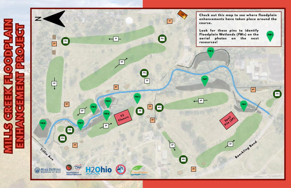
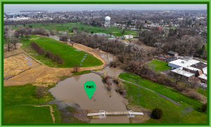
Mills Creek Floodplain Enhancement Project
Mills Creek Floodplain Enhancement Project
Funding: H2Ohio through ODNR Division of Wildlife Project
Status: In Progress
The Mills Creek Golf Course is located on a floodplain that accepts water from almost all of the 42.4 square mile Mills Creek watershed. This project will increase the ecological benefit of the course by creating additional flood capacity across 4 acres of designed wetlands, stabilizing nearly half a mile of streambanks, and establishing thousands of native wetland plants to provide pollinator and wildlife habitat. These newly constructed wetlands filter the water that enters them and allow suspended particles to settle, reducing both nutrient and sediment loads entering Lake Erie. Course patrons will also see benefits as the project should reduce flooding in all but the largest storms and allow for faster course drainage to limit course closures.
Why is this project important?
Fall of 2025 – Pre Construction
In 2016, the EPA designated Mills Creek an impaired stream due to excessive nutrient pollution within the watershed. The Mills Creek Floodplain Enhancement Project seeks to improve water quality by creating specialized areas outside of golf play that allow excess water from the creek to flow, sediments to settle, and native vegetation to thrive. This benefits golfers and local wildlife by decreasing flood severity on the course, reducing the sediment and nutrient load that enters Lake Erie, and improving habitat for native plants and wildlife that inhabit the course.
What are the goals of this project?
Fall of 2025 – Pre Construction
This project’s main goal is to improve the function of the floodplain to assist in filtering pollutants being carried in Mills Creek before they reach the Lake. By creating pools with inlets for water to flow, the construction will also provide increased holding capacity for flood waters in non-play areas of the course. Additionally, reinforcing the streambanks with rock will reduce erosion near play and help to preserve the course. Overall, these improvements should make the water cleaner and reduce the length of closures on the course after storm events.
How was this project funded?
This project brought $900,000 in funds through Governor DeWine’s H2Ohio water quality improvement initiative into Erie County to be used for design and construction.
What will the finished project look like?
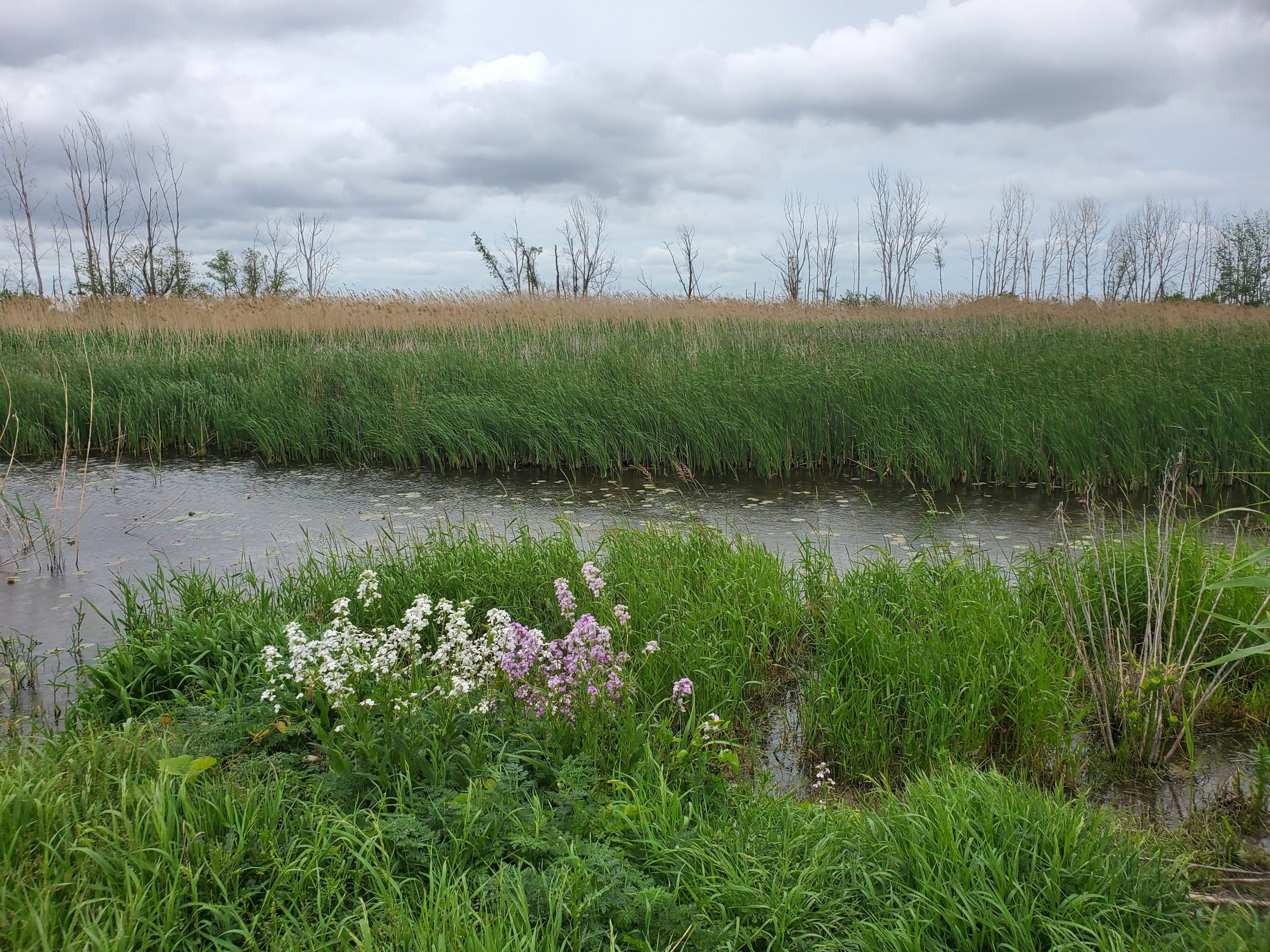
Areas outside of boundary markers and adjacent to the stream will be unmowed and may look “wild” but will include many native flowering species that will improve the visual interest of the course. Additionally, areas that flooded before may flood less often or less severely.
How long will Hole 3 be partially closed?
Construction impacts golf play most on Fairway 3. Because it has been raised and regraded, the fairway will flood less than in previous seasons, improving play for years to come. It can take turf grass months to fully establish, and the soil could need over 6 months to settle before cart and foot traffic can resume. Because of this, the hole may be altered most to all of this season. Please avoid impacting recovery by walking, driving, or playing within the fenced area.
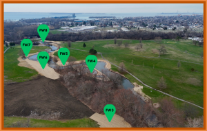
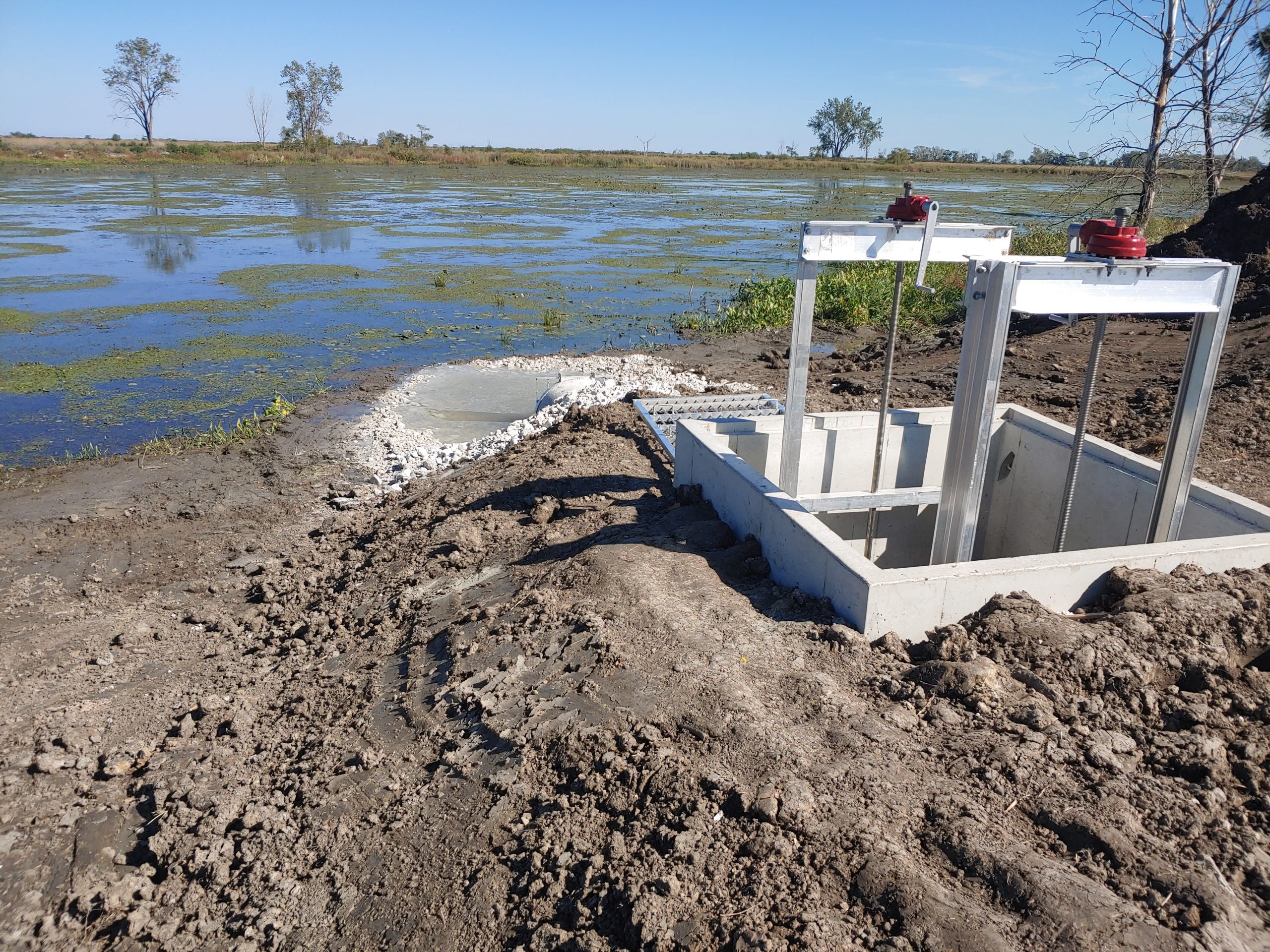
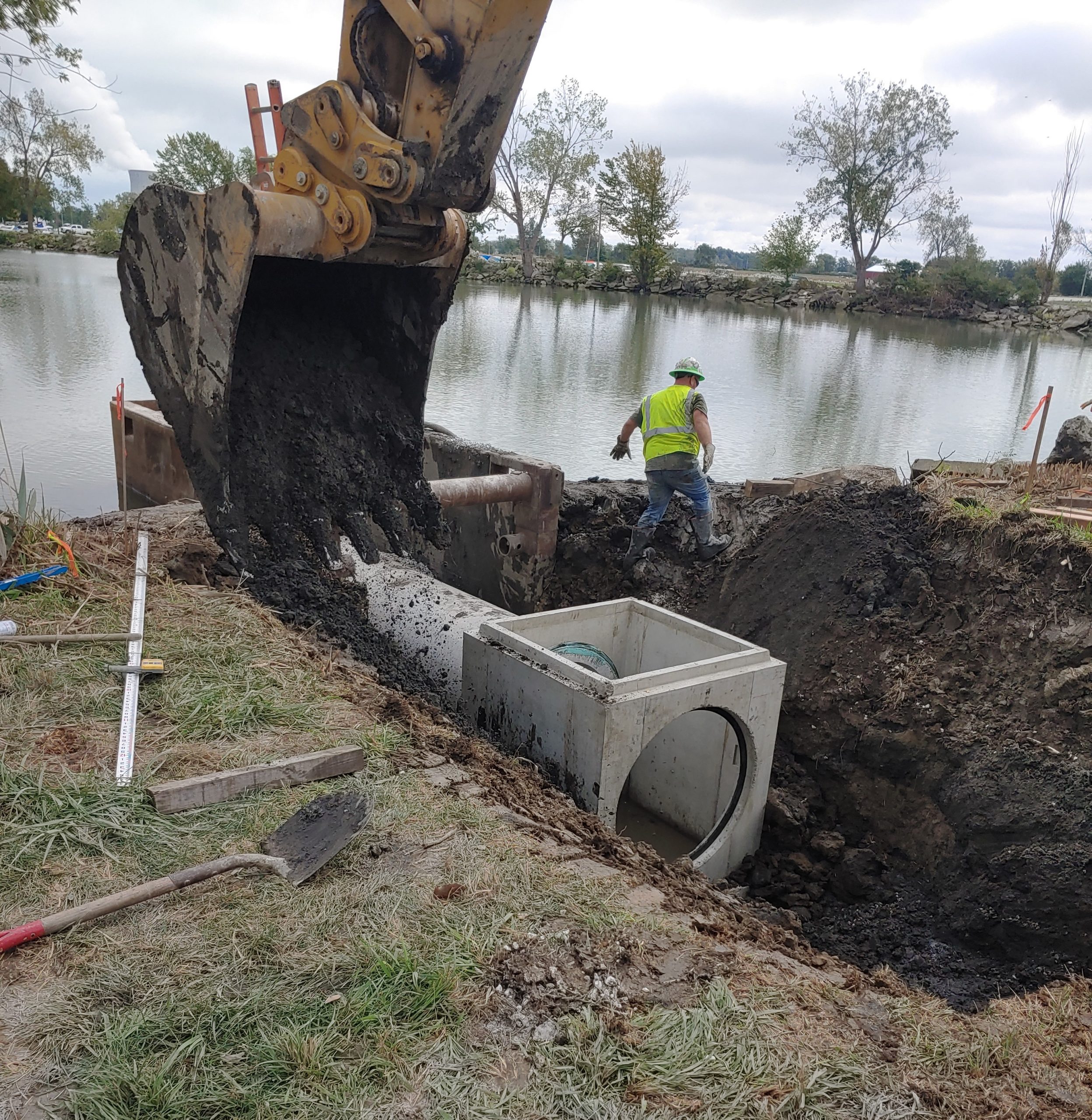
Designed wetlands and bank stabilization (wrapped in erosion control matting), fairway 3 regrading in progress.
When will the project be finished?
Major construction including earthmoving, stream realignment, bank stabilization, and woody plantings were completed before the 2026 season-opening of the course. To boost the establishment of floodplain vegetation, there will also be volunteer planting days in June and July. After these events, erosion control will remain in place until the end of the season and vegetation is established.
What has been planted?
Seven species of trees, two species of shrubs, 19 species of grasses and sedges, and 16 species of wildflowers were planted in the floodplain expansion areas! These species create habitat for pollinators, birds, and mammals. Special consideration was given to areas abutting play which have been planted with shorter vegetation to reduce play impact.
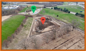
Designed wetlands near Hole 5 and spoil pile.
What are the project statistics?
- 8 wetland areas constructed totaling 4 acres along Mills Creek
- 2,000 linear feet of streambank stabilized with rock and native plants to prevent the loss of fairways and greens
- Flood protection berm installed near the storage buildings to prevent flood damage
- Approximately 1 acre of Fairway 3 raised and regraded to reduce the pooling of water after storms
How will we measure water quality improvements?
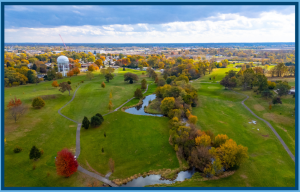
Designed wetlands taking in water after large rain event.
Mills Creek has been monitored by local volunteers since 2011. Over time, we will be able to track creek health before and after it interacts with the project to assess the water quality impacts of the floodplain.
Will this project solve course flooding?
The newly constructed wetlands will provide enhanced flood storage for the stream during 1-2 inch rainfall events. In larger storms (like the one pictured to the right), flooding will still occur, but because of the new construction, water will recede faster and play will be able to resume more quickly than past seasons.
Will this Project attract more geese?
Most golf courses provide the perfect habitat for Canada geese since they prefer open water and mowed grass. This project will create areas of vegetation tall enough to discourage geese in certain areas of the course, as taller vegetation can hide predators.
Is this project going to make mosquitos worse?
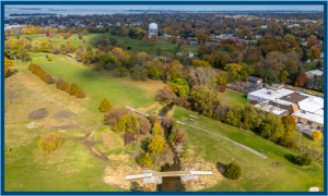
4″ of rain excedes designed wetland capacity but remains within floodplain zone without impacting Fairways 5 and 6.
Mosquito populations change yearly based on weather conditions such as temperature, rainfall, and humidity. Mosquitos can travel up to 3 miles from their breeding grounds, which include natural areas and standing water in residential areas like clogged gutters, tires, or buckets. While this project will create wet areas that could serve as breeding area for mosquitos, it will also create habitat for natural predators. This project should not significantly change the mosquito presence at the golf course.
Will more golf balls be lost?
Unfortunately, this depends more on the skill of the golfers than the course. Nearly all areas of the project are strategically located out-of-bounds. Still, we understand slices happen – in fact, during the construction of this project, over 15 5-gallon buckets of golf balls were collected! Warm up and work on your form to keep the balls in play.
Click to open Mills Creek Floodplain Enhancement Project PDF files.
Sanford Ditch Treatment Train
Sanford Ditch Treatment Train
Funding: H2Ohio through ODNR Division of Wildlife
Project Status: In Progress
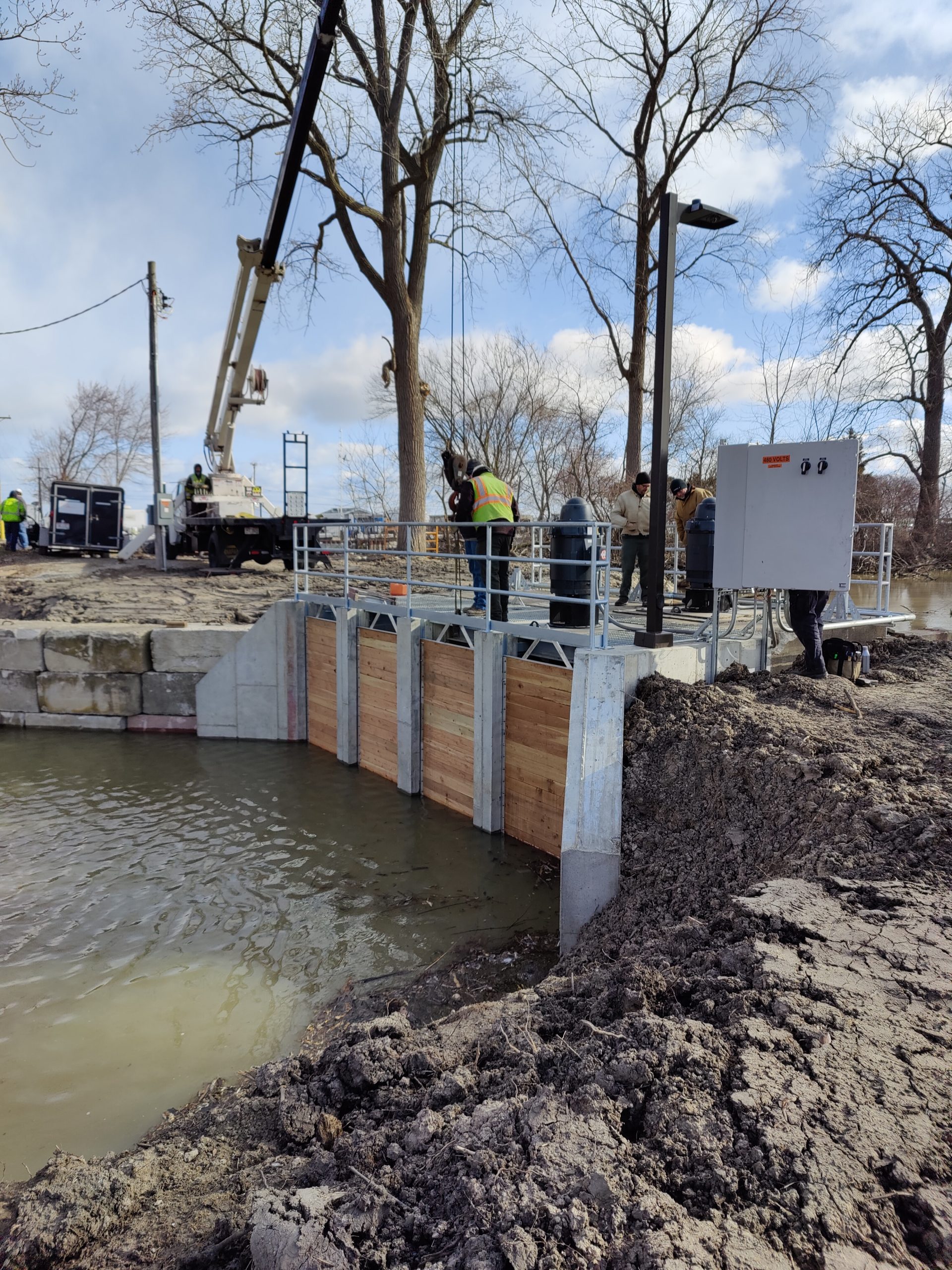
Sanford Ditch drains approximately 495 acres of agricultural land in Margaretta Township of Erie County. In the mid 1960’s the ditch was channelized, which cut off potential connection to coastal wetlands in the area and facilitated drainage directly to Sandusky Bay. With current high water, farmers and residents within this basin have experienced reduced drainage and even flooding which facilitates the release of phosphorus from the soil profile potentially increase contributions to Lake Erie. The project consist of a “treatment train” of practices including the creation of 680 linear foot overwide ditch and 2 acre wetland to serve as initial pretreatment then reconnect the ditch to Sanford Marsh via pump structure. The combination of conservation ditch with treatment wetland will provide drainage relief to the local landowner’s while helping to prevent nutrients and sediment from entering Lake Erie.
Moxley Marsh Wetland Reconnection
Moxley Marsh Wetland Reconnection
Funding: H2Ohio through ODNR Division of Wildlife
Project Status: In Progress
This project will reconnect 57 acres of emergent wetland to Sandusky Bay, near the Village of Bay View. The new connection will include fish passageways/water control structures at the northwest corner of the unit which will allow free water exchange between the wetland and the Bay when water levels are at the correct level. With this connection, the marsh help to remove nutrients from the Bay water as the water is exchanged between the two systems. In addition to the installation of a water control structure to reconnect the wetland to the lake, substantial rehabilitation of the levee will also be completed to protect the wetland. Over 3,000 linear feet of levee will be rehabilitated through earthen and rock stabilization techniques to improve integrity and reduce erosion.
Magee Marsh Pump Rehabilitation
Magee Marsh Pump Rehabilitation
Funding: GLRI through ODNR Division of Wildlife
Project Status: Completed 2022
Magee Marsh is part of a large 2200 wetland complex located near the Ottawa National Wildlife Refuge in Ottawa County. This project implemented the rehabilitation of a large pump structure that connected the main channel of Magee Marsh to Lake Erie. The process began by partially demolishing the existing pump structure then expanding the site to add and additional pump to the system. This expansion increased the management capacity of the structure to allow for greater exchange water in and out of the wetland complex. The greater exchange of water will allow the marsh to serve as a treatment site for removing nutrients and sediment from our Lake. In addition to water quality benefits, fish passage structures were added to structure to improve access of the wetland by local fish species.
Pipe Creek Wetland Restoration (Phase 1)
Pipe Creek Wetland Restoration (Phase 1)
Funding: GLRI through ODNR Office of Coastal Management
Project Status: Completed 2021
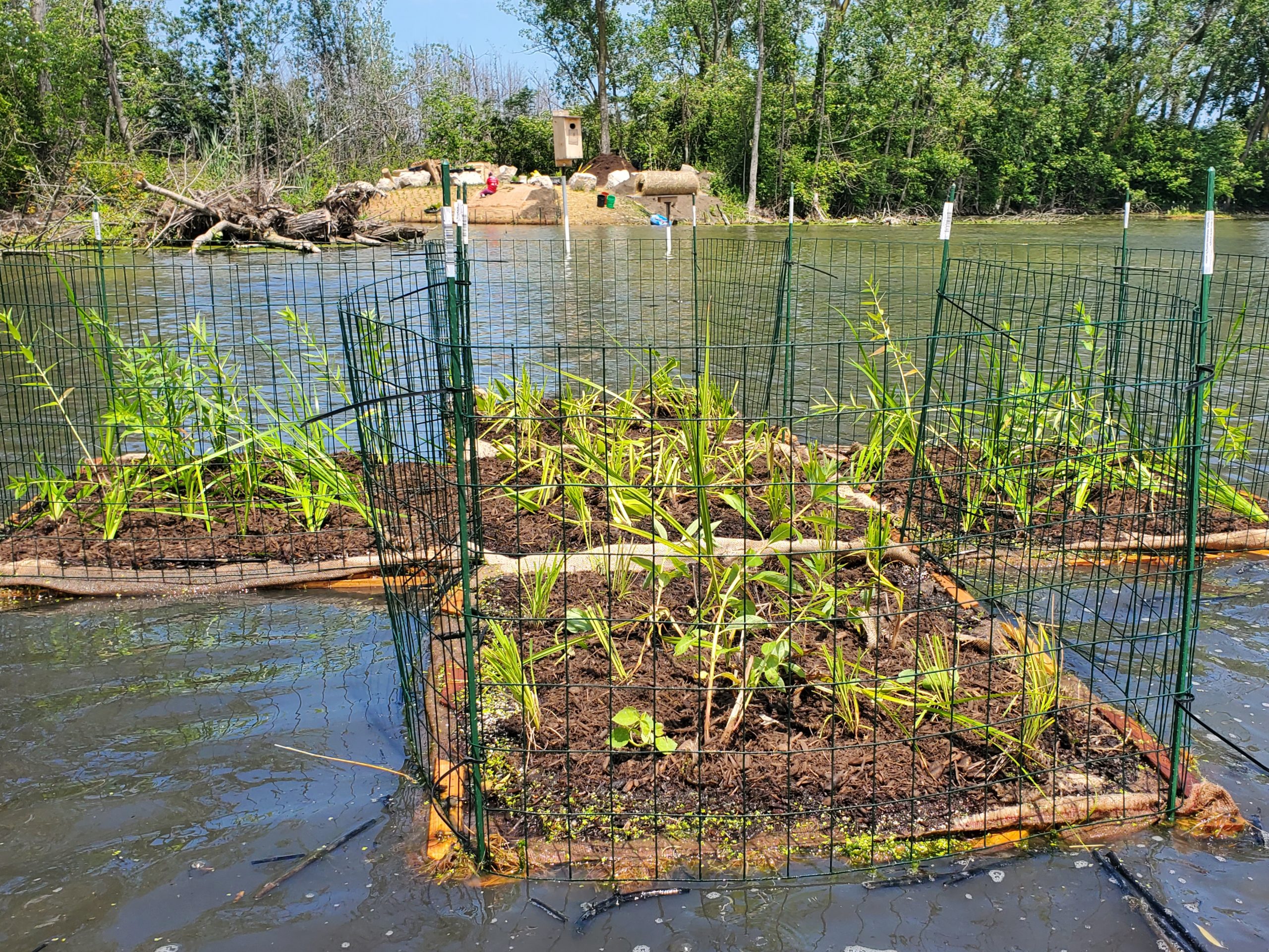
This project was initiated by the determination of local resident, Wanda Valli, who simply wanted to restore a wetland she saw degrade before her eyes for decades. It took nearly 15 years to get here, but though the help of volunteers, funders, and conservation agencies working together the enhancement of the coastal zone of the Pipe Creek watershed is finally becoming a reality. In the first phase of this project, a large opening was made in a manmade berm to improve the bi-directional flow that is common in coastal wetlands. This, followed by extensive removal of decades of dumping of soil, construction debris, trash, and slag. Over 70 large dump trucks of material was removed to make way for replanting the site with native hard wood trees. Control efforts began in 2019 for removing the invasive plant Phragmites from the emergent wetland, which later was revegetated through nearshore and floating wetland plantings. A combination of 76 biodegradeable floating wetlands upcycled from used wooden pallets were fashioned into 15 floating islands and 6 permanent Biohaven floating wetlands were planted and installed along the west side of the wetland. In addition to the floating wetlands, over 2,000 native wetland plugs installed in nearshore “nursery” areas to jumpstart the revegetation of the site.
Turtle Creek Wetland Reconnection
Turtle Creek Wetland Reconnection
Funding: H2Ohio through ODNR Division of Wildlife
Project Status: Completed 2021
This project reconnects 173 acres of wetland habitat to Lake Erie and Turtle Creek allowing the system to filter nutrients from an approximately 26,560 acre (41.5 square mile) watershed. To accomplish this, two large water control structures were installed into a levee along Turtle Creek to facilitate the capture of water from the surrounding water bodies. The structures will allow management of the water level in the wetland unit during agricultural runoff events or high seiche events (wind driven tides) from Lake Erie to allow the wetland to serve as a treatment site. The two structures are over one mile apart, which creates a pass-through system by diverting water from Turtle Creek into the wetland unit at one structure before exiting out another. This project also included repairs needed on the levee separating the wetland unit from the creek. This repair was important to maintain the vegetation needed to provide filtering and habitat functions of the wetland.